Patricia R. Zimmermann and Caren Kaplan
Throughout the month of March and into April, as the Covid-19 coronavirus circulated around the globe, footage of cities that seemed abnormally empty began to turn up on social media or posted to YouTube.
The imagery, usually produced by professional or amateur drone operators, has been presented in such strikingly similar ways that a specific genre may be emerging.
A conversation that began on Facebook when Hallwalls curator Edmund Cardoni posted drone footage from Buffalo New York, then emerging as the second coronavirus hotspot in New York State, instigated this Quorum column.
FQ editorial board member Patricia R. Zimmermann reposted the video and asked “is coronavirus drone footage a new genre?” Caren Kaplan, who works on aerial imagery and militarism, replied “Interesting! The iconic symbol of distance tech produces the imagery of social distancing.” A lively discussion ensued, leading B. Ruby Rich to invite them to develop the dialogue in Film Quarterly’s Quorum, links included.
This is not intended as a rush to join the coronavirus culture industry in advance of sufficient time to reflect meaningfully on what is happening.
Instead, it is an exploratory conversation that, to get first thoughts exchanged, nods to Raymond Williams with a keywords template to help organize this inquiry into coronavirus drone footage.
As the virus infiltrates the mediascape, this dialogue aims to open a space for preliminary musings, a process meant to be iterative and productive rather than fixed and final.
This drone footage is specific to the pandemic, but also, in other ways, not at all. Just as the virus emerges from and circulates via the material conditions of neoliberalism and globalization, there are powerful historical continuities that require substantial tracing, linking, and retracing to understand its emerging visual lexicon.
The swift-changing progression of the coronavirus and the cascading public health and economic disasters it has unleashed will require new ways to think about critical work on screens and machines.
Note: in the following exchange, K stands for Kaplan, Z for Zimmermann.
KEYWORDS
AFFECT
K: The drone footage that is circulating recently of emptied cities works strenuously to evoke a haunting, melancholic nostalgia for what has been lost.
Z: The affective response, the elegiac, seems like a form of romanticism available only to the privileged with time to meditate on emptiness and revel in it.
K: Drawing wittingly or unwittingly on a large cultural fund of imagery from the aftermaths of wars, the pandemic drone imagery does not so much reflect as produce the division between now and then, here and there, us and them, etc.
Z: Scholars have written about ruin porn, the elevation of a lost and destroyed past. Some of this drone material resonates with ruin porn, this time the ruins of neoliberal cities where the movement of global capital is stopped.
K: This “strange yet familiar” elegiac landscape masks the continuities of late capitalism’s inequalities. Streets and parks are shown to be eerily emptied of people “as never before” yet some of those very people may have been homeless, unemployed, working too many jobs, uninsured, worried, sad, lost.
How does a predilection for the dramatic representation of the empty streets and the affective responses such imagery evokes make it even less possible for the privileged to perceive the less privileged?
Z: Yes, for the uninsured, for essential health care and food workers, for doctors and nurses on the front lines of this disease, the affect is not one of haunting by the past but rage in the present: the insufficient PPEs, ventilators, hospital beds, contact tracing, testing.
CITIES
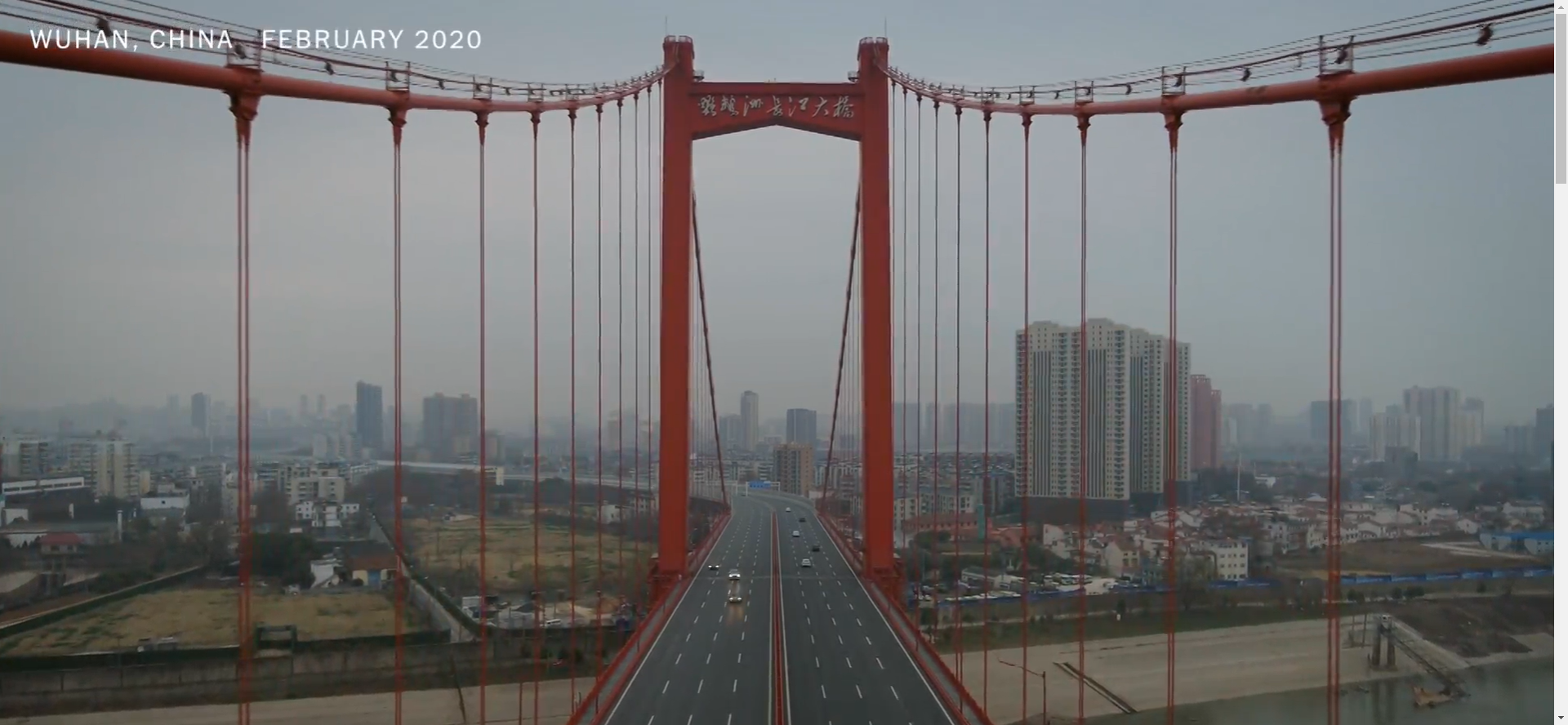
K: Aerial representation has almost always focused on cities—either imagined “bird’s eye” views or the first photographs from the air, as taken in the mid-19th century by Felix Nadar and his son from balloons either above Paris or nearby.
Z: There quickly followed: Boston, Budapest, Cape Town, Delhi, Denver, Dubai, Hong Kong, Kuala Lumpur, Lagos, Lahore, London, Los Angeles, Milan, Mumbai, Nashville, Paris, Prague, Riyadh, San Francisco. This drone video shows how empty Denver’s streets are right now.
Despite the initial “home video” drone shots, most of these were produced by major news organizations such as BBC, Channel News Asia, New York Times, Vice, and Washington Post.
K: Yet, looking back, before, during, and after World War I, the development of aerial photography depended on the clear air and arid climates of North Africa and the Middle East. It was there that colonial militaries worked through the potential for this new technology as an aide to reconnaissance and targeting (with a lot of energy expended in colonial policing through “air control”).
Z: Today’s coronavirus drones focus almost exclusively on urban landscapes in middle-sized and major cities rather than rural landscapes or small towns, exalting the built and overbuilt environments of bridges, roads, skyscrapers. Replete with Bollywood-style dance music, a video from New Delhi is entitled Incredible India: Before and After Lockdown, suggesting a transition between a past of contact and the future of absence.
K: Throughout the 1920s and 30s these rural spaces also assisted in the transformation of the science of surveying, for agriculture and industries like oil as well as for townships and cities.
Z: These images evoke a lineage of the city documentaries of early 20th century modernism such as A Propos de Nice (Jean Vigo, 1930), Berlin: Symphony of a Great City (Walter Ruttman, 1927), Man with a Movie Camera (Dziga Vertov, 1929), or even the opening scene of Triumph of the Will (Leni Riefenstahl, 1933).
K: The boom in commercial aviation in the 1920s accompanied this zest for surveying and the aerial view of cities became an iconic register of their modernity. So many movies establish location in their first moments through aerial imagery. Throughout film history, the opening aerial shot declaims, “you are here, in this modern space of progress and industry.”
Z: Those 1920s/1930s documentaries double what you describe in terms of commercial aviation, for they celebrated modernity by immersing people in the machines, transportation, and elaborations of the spatial relations of city people on the move.
The coronavirus drone pieces invert this tradition: now the drone is the machine that moves through space in a built environment devoid of crowds, a pattern of buildings (with people presumably inside), and an exterior of roads (with delivery vehicles and a lone bicyclist). They perform an elegy for the stoppage of global capital.
K: I agree—the aerial flyover in coronavirus drone imagery now conveys the message that modernity is in peril or decline.
DELIVERIES
K: The narrative that surrounds most of the pandemic drone clips emphasizes the disruption of everyday life and, throughout media coverage and online postings, the emptiness of cities. Yet, it is surprising to see how many vehicles are moving on the streets.
Z: Drones have also become vehicles in the supply chains of COVID. In Chennai India and Surabaya Indonesia drones sprayed disinfectant.
In China, they did medical deliveries. In Ghana and Rwanda, they delivered masks and gloves and COVID 19 test samples.
K: Less traffic, indeed—with excellent results almost immediately for air quality and the carbon footprint. But who has the choice to drive or not to drive during a pandemic outbreak? The massive increase in a reliance on deliveries during stay-at-home orders ensures that vehicles will stay on the road and cargo planes will fly. The drone imagery can capture these contradictions and tensions in infrastructure, supply chains, and labor relations for anyone who chooses to see that information in them.
Z: But then, drones in the age of Corona also operate as agents of state power. In Singapore, NParks flew drones in Bukit Timah Nature Preserve to monitor crowds for real time data.
Police used them in Elizabeth, New Jersey to monitor social distancing.
And in Westport, Connecticut, police announced in April that they would deploy a “pandemic drone” to monitor not only social distancing but also whether or not people are running a fever.
DEVASTATION
K: Images of emptied cities abound in the aftermath of calamities. The business of everyday life can only be interrupted by a force majeure—a war, a huge hurricane, a nuclear accident, a pandemic.
The advent of aerial photography, with its capacity to convey the broadest scale of devastation, coincided with World War I and reached its maturity with World War II. That imagery—of cities pulverized and rendered lifeless by shell fire or bombed from the air—resonates throughout the archive of aerial photography as a dominant trope, a horrifying punctum, a convenient symbol.
Z: Your point about devastation and its links to both war and aerial photography is so trenchant. In his daily press conferences, now with an international cult following for the science and public health based arguments that stand in opposition to the hysteria of the news and denials of the White House, New York Governor Andrew Cuomo likens the pandemic to a war. His clearly designed blue and gold PowerPoints provide data visualization of the rate of infection and death, while images in the background always show people working on the ground, the very opposite of the drone imagery.
In Cuomo’s press briefings, the devastation resides not in images, but in actual bodies, deaths, essential workers, and illness. The drones actually conceal the devastation of the pandemic, which lies in the deaths of people in hospitals and homes, hidden from the sightlines of the drone.
K: One question to consider—is it the drone itself as a sensor that collects data that conceals or is it a matter of mediation – the editing, narrative, and placing of the data into a generic framework?
DISTANCE
K: Most people think drones are the quintessential technology of distance; alienating, automatized, and objectifying.
Z: The drone videos insist that seeing still persists and still matters. But they are not seeing (nor showing) the virus or the nature of public health, which are not about distance but about bodies and how to protect them.
K: Yet research on the material operations of military drones has demonstrated conclusively that profoundly intimate relations can often result from the long-term patrol of enemies, while the use of sUAS (Unmanned Aircraft Systems smaller drones) by humanitarian groups and social movements has also been shown to create complex networks.
Z: That point pushes me to see that the coronavirus drone imagery actually camouflages material operations and complex networks, celebrating buildings rather than the social, political, and economic relations operative underneath these surfaces.
K: Similarly, perhaps because it seems to be produced at a distance, drone imagery is widely believed to be factual, data-based, and neutral. If every image produced by a camera is a form of remote sensing, the imagery produced by drones—whether from large-scale military drones or small sUAS—serves as the most remote and perhaps, to date, the most realist. In other words, distance is relational and historical and the ways in which discourses of distance are deployed may vary. During a pandemic when relations between communities and nations are under extreme duress, it is crucial to be alert to any uncritical reception of the powerful operations of remote sensing technologies.
Z: I find myself drawn to your phrase “distance is relational and historical” especially in terms of this coronavirus drone genre.
These videos excise the relational by displacing it onto the technological and the visual, but they also displace the profound social horror and hysteria of not seeing or knowing where the virus is: it is nowhere, elsewhere, everywhere, impossible to visualize with the human eye.
GHOST TOWNS
Z: The words used to describe these coronavirus drone videos in the news stories, YouTube descriptions, and social media repostings map a semiotics of mourning: desolate, deserted, devoid, empty, gloomy, haunting, post-apocalyptic, sad, lonely.
K: When I think of ghost towns I always return to Freud’s Mourning and Melancholia, not to advocate for a purely psychoanalytic analysis but to appreciate at least one key insight in the work—among the differentiations between mourning (which ends eventually) and melancholia (which has no end), Freud wrote that the melancholic believes that a loss has occurred but “cannot see clearly what it is that has been lost.”
Z: The slow movement of the drone over formerly congested streets now speckled with a lone car or truck or person constitutes a visual register of grieving, loss, and mourning. Illness and death surge beyond the image, as invisible as COVID-19.
Consider the scenes from Gulf News of drones being used to sterilize the streets of Dubai in the middle of the night. These images mourn the loss of sociality and physical contact of pre-COVID-19 life, constituting elegies for a past no longer available or tenable, a past of tactility and affect that is now dead.
K: It is not only time that is jumbled and discontinuous for the melancholic, but also space. The drone footage of cities less peopled than usual focuses on the absence of foot traffic and fewer cars but the repetition of the imagery (its generic sameness) speaks to what we cannot “see clearly,” namely the sick and the dead. This is the nature of haunting: a compulsion to see the worst through means which continually mask that reality.
Z: Consider the pandemic technological inverse of the drone images: the Zoom and FaceTime images that insist on the close-up, the inside of homes, the intimate, the lack of movement, the verbal. Now, it is a world without medium shots, only the close-ups of Zooms and the aerial long shots of drones.
LIFE FORMS
K: Cities under lockdown are empty! Or so the clips of drone imagery during pandemic announce. However, everyone knows otherwise. Coyotes and jackals have been seen in the downtowns and open spaces of suburban malls. Deer walk through neighborhoods. Water fowl in large numbers return to ponds and lakes in city parks. With less resources for groundskeeping, the weeds take advantage. People who are not restricted by direct curfews are out walking or driving in any way they can manage. Life forms abound in the cities and towns. Drone imagery could capture at least some of these forms of life. What is it about the genre of representation chosen by operators and editors that forecloses these modes of representation?
Z: The persistence of life forms—animals, weeds, people—constitutes a pinprick in all these pandemic drone shots. The pandemic urban drone shots operate in an ontological twist where they marvel in the new emptiness of the metropolitan areas but evoke a computer- generated landscape where digital technologies remove humans. They look “real”’ but feel “unreal”, they are analog but seem digital.
So, these life forms erupt, reminding viewers that the gaze at the environment is an entanglement of the built and the natural, performing a deconstruction of the smooth glide over streets and buildings with their own movements, an assertion of the micro over the macro.
Here, drone footage shows empty streets in Lahore, Pakistan, amid the coronavirus lockdown.
SOUNDSCAPES
Z: Three soundscapes seem prevalent in the coronavirus drone genre: electronic music, silence, and everyday sounds.
K: I notice sound but I know little about it so my first impression when moving through the recent coronavirus drone footage streaming online was that the soundtracks all sounded the same. By “same,” I mean that I noticed electronic music, somewhat abstract or repetitious, that seemed to evoke a gloomy or sad emotion.
Z: The massively reposted drone footage from Wuhan on the New York Times site features repetitive, non-directional electronic sound with looping effects. Footage of Boston uses a pulsing, repetitive beat, looping, layers of electronic beats, ethereal, slow, spatial, like music pumped into a spa. Ambient machine-made music in a post-minimalist style distantiates, doubling the distancing of the visuals.
K: This immediately connected to my thoughts on melancholia and urban aerial footage as wartime aftermath—the unspooling, endless evocation of grief over long histories of absence and violence at numerous scales that is presented as “everyday militarism” (normalizing) or as triumphalist overview (fascist spectacle).
Z: In footage from London, the music uses loops. The music is machine-produced and digital, with no analog instruments, slow, repetitive. Yet drone footage from Russia of the construction of a 500-bed hospital employed pulsing electronic music, like dance music.
K: The silent footage is more enigmatic or, even, boring. It seems more amateurish and leaves its viewers to their own thoughts without the need to be pushed around affect-wise by the allure of the kind of sound that accompanies the more commercially-produced works.
Z: Some drone footage features no sound at all, for example, images from Los Angeles or Nashville or Paris, in which the visual is evidentiary and empirical, isolated from other senses.
Finally, the musique concrète of some other drone pieces, such as the Washington Post images from Washington DC, where everyday sounds of birds, escalators, a few cars, motorcycles, and planes mingle into ambient tracks, offers up sounds unheard in density: the sounds of isolation.